
News Desk :
The coastal districts may face heavy rains and flooding during the passage of Cyclone Yaas as the “very severe” storm in the Bay of Bengal dashes towards India, reports agencies.
Bangladesh Meteorological Department said on Tuesday the storm over northwest bay was likely to move further northwestwards and cross North Odisha-West Bengal coasts by Wednesday noon.
Maximum sustained wind speed within 64 kms of the cyclone’s centre is about 89 kph rising to 117 kph in gusts or squalls. Sea will remain high near the centre.
The Met Office asked the maritime ports to raise the warning signal to No. 3.
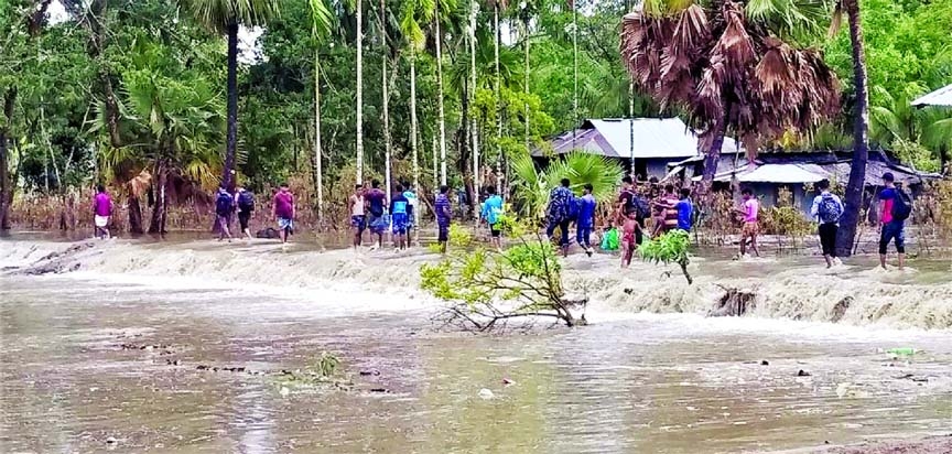
Khulna, Satkhira, Bagerhat, Jhalokathi, Pirojpur, Borguna, Patuakhali, Barishal, Bhola, Noakhali, Laxmipur, Feni, Chandpur and Chattogram and their offshore islands and shoals are likely to experience wind speed of up to 80-100 kph in gusts or squalls with heavy to very heavy falls during the passage of the storm.
Under the influence of the full moon phase, the low-lying areas of these districts are likely to be inundated by astronomical tide of two to four feet above the normal height.
All fishing boats and trawlers have been advised to remain in shelter until further notice.
The authorities have also shut all river transports until further notice. “The announcement has been made as an additional precaution so that no lives are lost,” said Mizanur Rahman, a deputy director of the Bangladesh Inland Water Transport Authority or BIWTA.
Meteorologists forecast that the cyclone will bypass Bangladesh if it maintains its current course.
However, the storm could threaten the habitat of many creatures in the Sundarbans if it crashes into the coasts during full moon which will create huge tidal waves.
India began moving more than a million people to safety on its east coast on Tuesday as the cyclone neared, days after a deadly cyclone hit the west coast.
“It is likely to cause large-scale damage,” India Meteorological Department chief Mrutyunjay Mohapatra told media.
Meanwhile, the maritime ports of Chattogram, Cox’s Bazar, Mongla and Payra were advised to hoist local cautionary signal number three on Monday evening instead of distant warning signal number 2 as the depression over the Southeast Bay and adjoining Andaman Sea intensified into cyclonic storm ‘Yaas’.
The severe cyclone storm ‘Yaas’ over Northwest bay and adjoining area moved north-westwards further and now lies over the same area.
In a special weather bulletin, the Met Office said at 3 pm today, it was centered about 520 kms Southwest of Chattogram port, 520 km Southwest of Cox’s Bazar port, 425 km South-southwest of Mongla port and 420 km South-southwest of Payra port.
It is likely to move northwestward further and may cross Odisha-West Bengal coast by Wednesday noon (26 may 2021).
Maximum sustained wind speed within 64 kms of the severe cyclone centre is about 89 kph Rising to 117 kph in gusts/squalls or squalls, the bulletin said.
Sea will remain high near the severe cyclone centre.
All the fishing boats and trawlers over the North Bay and deep sea have been advised to remain close to the coast and proceed with caution. They were also advised not to venture into the deep sea.
