
World War II
US Navy sailors in Chittagong, 1944
During World War II, the British used Chittagong as an important military base. Frequent bombardment by the Japanese Air Force,[clarification needed] notably in April 1942 and again on 20 and 24 December 1942, resulted in military relocation to Comilla. Nevertheless, the war had a major negative impact on the city, with the growth of refugees and unevenness in fortune, reflected in the Great Famine of 1943.
Post-war expansion
After the war, rapid industrialisation and development saw the city grow beyond its previous municipal area, particularly in the southwest up to Patenga, where Chittagong International Airport is now located.[2] The former villages of Halishahar, Askarabad and Agrabad became integrated into the city.
East Pakistan
The Chittagong Development Authority (CDA) was established by the government of East Pakistan in 1959 to manage this growth and drew up a master plan to be reviewed every five years to plan its urban development. By 1961 the CDA had drawn up a regional plan covering an area of 212 square miles (550 km2) and a master plan covering an area of 100 square miles (260 km2).[2] Over the decades, especially after the losses of 1971, the master plan developed into several specific areas of management, including the Multi-Sectoral Investment Plan for drainage and flood-protection of Chittagong City and a plan for easing the traffic congestion and making the system more efficient.
In 1971, during the Bangladesh Liberation War, Chittagong suffered massive losses in people and buildings given that they denied the occupation army access to the port. The first public announcement was made over the radio from the Swadhin Bangla Betar Kendra located at Kalurghat, Chittagong. Following the independence of Bangladesh, the city underwent a major rehabilitation and reconstruction programme and regained its status as an important port within a few years.
2. Chittagong Port
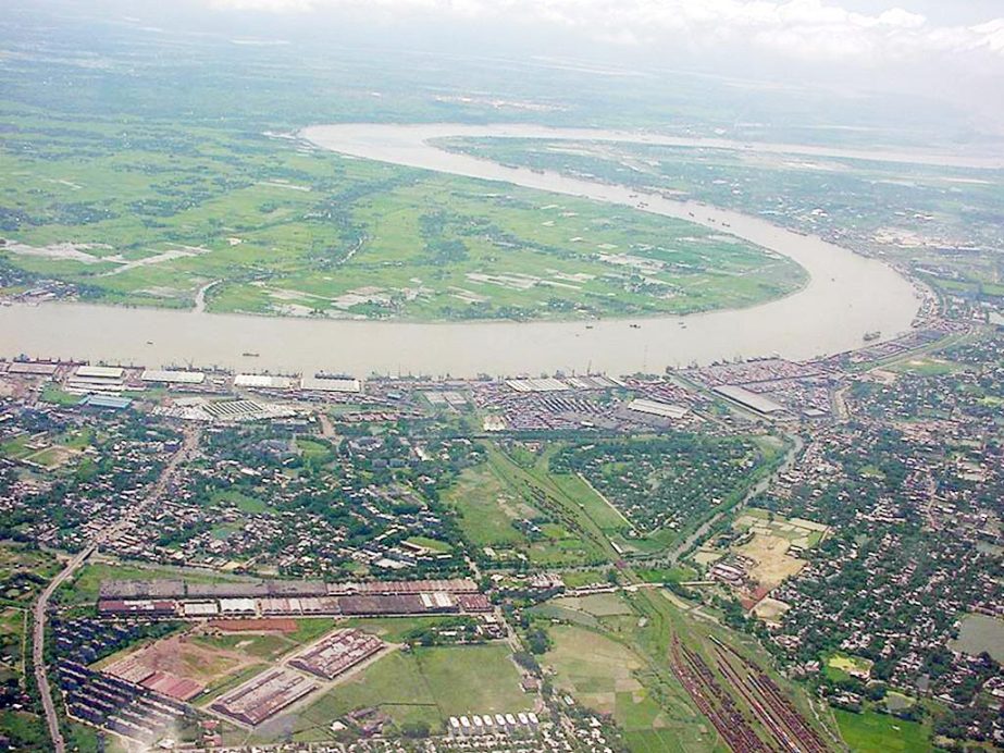
The Port of Chittagong is the principal Port of the People’s Republic of Bangladesh. It is situated on the right bank of the river Karnafuli at a distance of about 9 nautical miles from the shore line of the Bay of Bengal. River Karnafuli rising in the Lushai Hill falls in the Bay of Bengal after taking a winding course of 120 nautical miles through the districts of Chittagong Hill Tracts and Chittagong.
SEAWARD LIMIT
With Patenga Beacon as centre if an arc is drawn seaward with a radius of 5.5 nautical miles till it intercepts the coast line at positions :-
Lat 220 18’45” N. Long. 91046’30″E in the North and Lat 22008’13″N.Long 91050’00″E in the South, the area enclosed within the extremities if the arc will from the Seaward limit of the Port of Chittagong.
UPPER LIMITS
Upper limits of the river water are formed by two straight lines, one drawn across the Karnafuli River in the North by joining two pillars located at:-
These limits include so much of the sea and of the River Karnafuli and the River Halda and the area that lie within 137.162 Metre, of high water Mark at ordinary spring tide and the docks, wharves, quays, stages, jetties, piers, warehouse, sheds, railway line and yards within the limits of the bounded area and such other area outside it as included in the Schedule iii of the Chittagong Port Act.?
The seaward approach to the Port of Chittagong may be considered to be northwards of the 10 fathom contour in latitude 22024′ North and longitude 9103″ East: The distance to the pilot ground from the south patches shoal being 46 nautical miles on direct course.
The Port has the following recommended Anchorage Grounds:-
ANCHORAGE “A” is formed by extending 2 (two) lines upto Port limit, one (first) having bearing 337045′ and the other (2nd) 310030″ from the point having lat 22012’30″N and long 91047’00″E.
ANCHORAGE “B” is formed in between 2nd and 3rd line having bearing 2340 extended upto Port limit from the previous point.
ANCHORAGE “C” is between 4th and 5th line having bearing 234) & 157) respectively, extended upto Port limit from a point of lat 22012’00″N long 91047’12″E.
The space between 3rd and 4th line is prohibited anchorage. “A” Anchorage is for vessels over 30ft. draft. “B” Anchorage is for vessels entering the Port within 24 hours. “C” Anchorage is for vessels lightening and other vessels not schedule to enter the Port within 24 hours. The following Navigational Aids guide ships to approach the Port of Chittagong.
Service, facilities
Pilotage is compulsory for ocean going vessels. The entrance to the river is constantly changing and no vessel should attempt to enter without pilot. Pilot boards approximately 2 nautical miles seaward of the outer Bar Buoy.
In the moderate heavy weather a lee must be made for the Pilot Boat. The vessel receiving a Pilot is required to wait at the pilot ground near the entrance all clear of anchor taking into consideration the effect of tide and other conditions to facilitate boarding of the pilot in good time to be able to avail of the tide for entering and berthing etc. The propelling distance from the pilot ground to the main jetties is approximately 11 nautical miles and the distance has to be covered at variable speed in defferent sections of the river. Inward ships must present themselves at pilot ground at least 3 hours before the high water to enter on a particular day. This of course, is subject to the availability of berth and having permissible draft and length etc.
The ship movements generally commence about 5 to 5 hours before the day’s high water and the tides have been termed Day or Night taking this factor into consideration.
During the spring tide/Freshet/Foul weather vessels under 7 knots will not be normally handled and such vessels will be classed grade 2 for operation purpose. Agents of such vessel are required to consult the Deputy conservator well in advance.
Masters are advised to manoeuvre with great care while receiving and disembarking pilots.
Vessels due for entering in the next 24 hours must anchor in Anchorage B. Keep R.T. Watch at least 3 hours before the pilot boarding time and also display her signal letters.
Incoming vessels normally enter with the flood time. The normal manoeuvre is to snub with the starboard anchor and proceed to berth/mooring after heaving up and finally go alongside using the port anchor.
Night navigation
Night Navigation vessels upto 153.00M length with draft having 0.50M less than the days permissible draft will be allowed to take berth during Night (6 pm to 6 AM) at the Jetties from J/ltoj/13, MPB/1, MPB/2, DDJ/1, DDJ/2 and CUFLJ only.
Vessels with midship bridge upto 165.00 m & Vessels with AFT. Bridge upto 153.00 M Length having 0.30m (1.ft) Less than the day’s permissible draft will be allowed to sail out during Night from j/1 to j/13, MPB/1, MPB/2, CCJ, GSJ, TSP, DOJ. DDJ/1, DDJ/2, & CUFL only.
Vessels with bridge on the BOW & vessels having containers on deck obstructing clear view of forward, will not be handled during night.
Vessel will not be allowed to take berth at or to sail out from jetty no.14,15,17, RM/3, RM/5, RM/6, RM/8 & RM/9 During night.
CPA’S JETTY BERTH
There are 15 Jetties of which 13 are provided with shore cranes and Railway tarcks, 11 are provided with Transit sheds. Vessels upto 185.91 M (LOA) may be berthed at a single cement concrete main Jetty. Backyard facilities are there for handling container/container cargo vessels.
PUBLIC SECTOR JETTIES
For bulk cargoes like Wheat, Cement Clinkers, Rock Phospates and Urea Fertilizer etc. the following Jetties are available.
(A) FOR OCEAN GOING VESSELS
1) Cement Clinker Jetty for vessels upto 167.63M.
2) Grain Silo Main Jetty for vessels upto 185.91 M. LOA.
3) T.S.P Jetty for Vessels upto 175.25M.
4) DDJ/1 & DDJ/2 Two or more vessels having total LOA 302M and having draft not more than 7.00 M may be berthed.
5) Chittagong Urea Fertilizer Jetty for Vessels upto 176M. can be loaded upto maximum draft of 8.50 M.?
6) KAFCO-1 (UREA) & KAFCO-2 (AMONIA) Vessels having maximum length upto 185.91M and be loaded upto maximum draft of 9.14 M. (To be commissioned soon).
